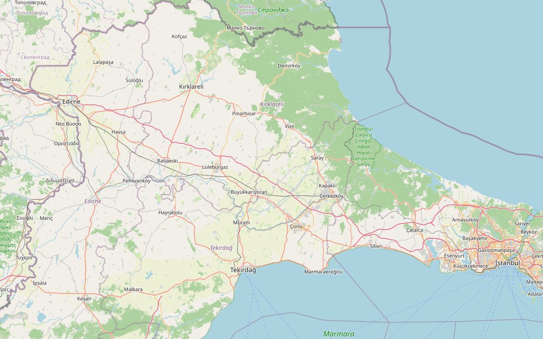
Most riders crossing at Kapıkule head straight down the motorway to Istanbul. This route takes the slow way through Thrace instead. After Edirne it runs on country roads through Süloğlu to Kırklareli, then follows the D020 along the southern edge of the Strandzha (Yıldız) hills through Pınarhisar and Vize to Saray. From there it heads south past Kapaklı to Çatalca, and only the last stretch uses the Avrupa Otoyolu (European Motorway) into the city. Read the tolls guide before you get there.
The ride is 330 km, split into two days with a night in Kırklareli; you could also spend the first night in Edirne. The highest point is 409 m, near Kırklareli. Fuel is easy except between Süloğlu and Kırklareli, where the gap is about 45 km.
Along the way
- KapıkuleWith Kapitan Andreevo on the Bulgarian side, it is described as Europe's busiest land border crossing. The D100 starts here.
- EdirneSinan built the Selimiye Mosque in the 1570s and counted it as his masterpiece; it has been on the UNESCO World Heritage List since 2011. Every summer the Kırkpınar oil wrestling festival takes place at Sarayiçi.
- SüloğluFill up here or in Edirne: the next fuel station is about 45 km away, near Kırklareli.
- KırklareliThe provincial capital and the overnight stop. To the north rise the Strandzha (Yıldız) mountains, with Dupnisa Cave near Demirköy, open from mid-May to mid-November.
- PınarhisarAncient Brysis, named for its springs. The Ottomans took it in 1368, and a Byzantine-era fortress survives.
- VizeA Cittaslow town. Its Byzantine Hagia Sophia church later became the Gazi Süleyman Paşa Mosque. Kıyıköy, a Black Sea village inside Byzantine walls, is about 36 km away.
- SarayThe town sits below the Strandzha hills, home to Thrace's only stands of Austrian pine. Descendants of the Crimean khans settled here in the 18th century.
- ÇatalcaOn the ridge between the Marmara and the Black Sea. In November 1912 the Ottoman army stopped the Bulgarian advance on the Çatalca Line, the last defence before the capital.
- IstanbulThe route ends at Eminönü. Our Istanbul riding guide covers bridges, ferries and parking.
Elevation profile
Green ticks mark fuel stations. Hover the chart to read the height at any point.
78 fuel stations sit within 400 m of the road. The longest stretch without one is 45.2 km, between km 39.2 and 84.4 (Edirne to Kırklareli). Any bike with a normal tank covers that without planning.
- 45.2 km (km 39.2–84.4)
- 31.8 km (km 94.8–126.6)
- 24.0 km (km 248.4–272.4)
Stages
| Section | km | Time |
|---|---|---|
| Day 1: Kapıkule → Kırklareli | 124.9 | 2 h 20 min |
| Kapıkule → Edirne | 18.2 | 0 h 23 min |
| Edirne → Süloğlu | 33.3 | 0 h 36 min |
| Süloğlu → Kırklareli | 73.4 | 1 h 21 min |
| Day 2: Kırklareli → İstanbul | 205.8 | 2 h 59 min |
| Kırklareli → Pınarhisar | 18.2 | 0 h 20 min |
| Pınarhisar → Vize | 25.2 | 0 h 22 min |
| Vize → Saray | 29.4 | 0 h 33 min |
| Saray → Çatalca | 77.0 | 0 h 56 min |
| Çatalca → İstanbul | 56.0 | 0 h 48 min |
When to ride
April to June and September–October are best. Summer is warm rather than hot. Winter brings cold, wet days to Thrace, and the Strandzha hills can see snow.
Fuel cost
Default price: Antalya petrol, 2 October 2026.
GPS track
The full route as a GPX file, for Garmin, Calimoto, Kurviger and most navigation apps.
Download GPXMeasured: 4 November 2026