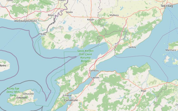
This is the first ride for anyone crossing from Greece at İpsala and heading for the Aegean. From the border it runs east to Keşan, where it turns south onto the D550. The road crosses the hills at the neck of the Gallipoli peninsula, passes Bolayır and Gelibolu, then follows the Dardanelles down to Eceabat and Kilitbahir. From either town a ferry crosses to Çanakkale in about 25 minutes.
The ride is 154 km and an easy half day, which leaves time for the border and a stop at the battlefields. The highest point is 345 m, south of Keşan. There is no fuel station on the route for the last 50 km after Gelibolu, so fill up there.
Along the way
- İpsalaOne of the main crossings between Greece and Türkiye, on the Meriç (Evros) river, which forms the border. The flood plain around the town grows İpsala rice, a registered regional product.
- KeşanA market town where the İpsala–Istanbul road meets the D550 to Gelibolu. It lay on the Roman Via Egnatia.
- BolayırThe tombs of the poet Namık Kemal and of Süleyman Pasha, Orhan's son, stand here above the narrow neck of the peninsula.
- GeliboluSüleyman Pasha took the town in 1354 after an earthquake, the first Ottoman foothold in Europe. The Piri Reis Museum is in a tower of the Byzantine fortress. The town is known for sardines. Last fuel for about 50 km.
- Gallipoli battlefieldsThe peninsula is a protected historical area. Anzac Cove, where Australian and New Zealand troops landed on 25 April 1915, is on the west coast, a short detour from the route.
- EceabatThe nearest town to the battlefields, busiest around 18 March and 25 April. Ferries cross to Çanakkale and carry motorcycles.
- KilitbahirMehmed II built the castle in 1462–63; seen from above it is shaped like a clover leaf. It is now a museum. A ferry crosses from here to Çanakkale too.
Elevation profile
Green ticks mark fuel stations. Hover the chart to read the height at any point.
23 fuel stations sit within 400 m of the road. The longest stretch without one is 50.9 km, between km 103.4 and 154.3 (Gelibolu to Çanakkale). Any bike with a normal tank covers that without planning.
- 50.9 km (km 103.4–154.3)
- 19.8 km (km 43.6–63.4)
- 16.6 km (km 63.4–80.0)
Stages
| Section | km | Time |
|---|---|---|
| Day 1: İpsala → Kilitbahir | 154.4 | 2 h 31 min |
| İpsala → Keşan | 28.2 | 0 h 23 min |
| Keşan → Bolayır | 54.0 | 0 h 39 min |
| Bolayır → Gelibolu | 18.4 | 0 h 15 min |
| Gelibolu → Eceabat | 48.8 | 1 h 8 min |
| Eceabat → Kilitbahir | 5.0 | 0 h 6 min |
When to ride
April to June and September–October are best. Summer is warm and busy around the battlefields. Late March and late April bring large crowds for the 18 March and Anzac Day ceremonies.
Fuel cost
Default price: Antalya petrol, 2 October 2026.
GPS track
The full route as a GPX file, for Garmin, Calimoto, Kurviger and most navigation apps.
Download GPXMeasured: 4 November 2026