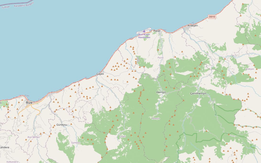
This short ride leaves the coast road at Pazar and turns inland up the Fırtına valley, a steep, forested gorge lined with old stone bridges. The road narrows and starts climbing at Çamlıhemşin, and ends at Ayder, the best-known yayla below the Kaçkar Mountains. The first 37 km follow the same D010 used by the Black Sea coast route.
It is 84 km in total. The road climbs from sea level to about 1,250 m at Ayder, and almost all of that height comes in the last 18 km after Çamlıhemşin. There is no fuel on that last section, so the longest gap is about 20 km. Fill up before you leave the valley floor. You can ride it in half a day, but most riders stay the night in Ayder and use it as a base for the higher yayla roads.
Along the way
- RizeThe capital of Turkish tea. The first trial tea plantings in the province were made in 1912, and the hills around the town are now covered in tea terraces.
- PazarA tea town 37 km east of Rize. Just west of the centre, the small medieval Kız Kulesi tower stands on a rock islet off the shore.
- Fırtına valleyHere the route turns inland from the coast. More than 20 Ottoman-era stone bridges cross the Fırtına and its side streams. Their high arches were built to stand up to the valley's floods, and the oldest dated one, at Şenyuva, is from the late 1600s.
- ÇamlıhemşinA small town at about 300 m, at the heart of Hemşin country. Look for wooden houses with steep roofs, and try muhlama, the local dish of melted cheese and butter. Fill up here, because there is no fuel on the climb to Ayder.
- Zilkale (side trip)Instead of turning for Ayder, carry on up the main valley about 15 km beyond Çamlıhemşin to reach this 14th–15th-century castle on a forested spur at about 1,130 m.
- AyderThe end of the route, about 1,250 m up and 18 km from Çamlıhemşin. The hot springs here are mentioned in official records from 1871, and the state made Ayder a tourism centre in 1987. It has waterfalls, forest, and honey from hives hung in the trees.
- Huser and the higher yaylasNarrower roads go on from Ayder to summer pastures such as Huser, Gito, Pokut and Sal. The road towards Huser was finished in 2007.
- Kaçkar MountainsThe range above Ayder has been a national park since 1994. Its highest summit, Kaçkar Dağı, is 3,937 m.
Elevation profile
Green ticks mark fuel stations. Hover the chart to read the height at any point.
17 fuel stations sit within 400 m of the road. The longest stretch without one is 19.6 km, between km 64.4 and 84.0 (Pazar to Ayder). Any bike with a normal tank covers that without planning.
- 19.6 km (km 64.4–84.0)
- 17.8 km (km 19.4–37.2)
- 17.6 km (km 46.8–64.4)
Stages
| Section | km | Time |
|---|---|---|
| Day 1: Rize → Ayder | 84.1 | 1 h 12 min |
| Rize → Pazar | 37.5 | 0 h 29 min |
| Pazar → Çamlıhemşin | 28.8 | 0 h 24 min |
| Çamlıhemşin → Ayder | 17.8 | 0 h 19 min |
When to ride
June to September is best. Ayder is a summer yayla with no year-round village, the coast is wet in every month, and in winter snow reaches the upper valley.
Fuel cost
Default price: Antalya petrol, 2 October 2026.
GPS track
The full route as a GPX file, for Garmin, Calimoto, Kurviger and most navigation apps.
Download GPXMeasured: 3 November 2026