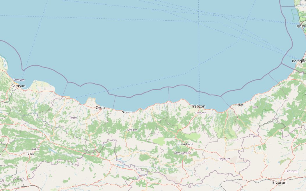
The D010 follows the Black Sea shore from Samsun almost to the Georgian border. It is a divided highway for most of its length, built in long sections on land filled into the sea, with green mountains rising straight behind it.
The 498 km are easy riding and fuel stations are close together; the longest gap is about 27 km. The appeal is in the stops: castles and beaches around Ünye, hazelnut country around Ordu and Giresun, Trabzon's Hagia Sophia and the inland Sumela monastery, and Rize, home of Turkish tea. The plan below takes three days, with nights in Giresun and Trabzon.
Along the way
- SamsunAtatürk landed here on 19 May 1919. A full-size replica of the steamer Bandırma, with a museum on board, stands in the Canik district.
- ÜnyeA castle dating back to the Pontic era, and Uzunkum, one of the longest beaches on the Black Sea.
- OrduCentre of Türkiye's hazelnut growing. A cable car climbs from the seafront to the Boztepe viewpoint at about 550 m.
- GiresunIts ancient name is linked to the word for cherry, and tradition says cherries reached Europe from here. Giresun Island, about 1.2 km offshore, has ruins tied to the legends of the Amazons and the Argonauts. Overnight stop.
- Giresun to TrabzonThe longest leg of the trip, about 133 km along the shore past Tirebolu.
- TrabzonThe 13th-century Hagia Sophia, built under the Empire of Trebizond, keeps its frescoes. Sumela monastery, set into a cliff at about 1,200 m above the Altındere valley at Maçka, is a side trip inland. Overnight stop.
- RizeHome of Turkish black tea and of the state tea company Çaykur.
- HopaThe end of the route, about 18 km from the Sarp border crossing into Georgia.
Elevation profile
Green ticks mark fuel stations. Hover the chart to read the height at any point.
238 fuel stations sit within 400 m of the road. The longest stretch without one is 27.2 km, between km 116.6 and 143.8 (Ünye to Ordu). Any bike with a normal tank covers that without planning.
- 27.2 km (km 116.6–143.8)
- 18.0 km (km 425.8–443.8)
- 16.6 km (km 470.6–487.2)
Stages
| Section | km | Time |
|---|---|---|
| Day 1: Samsun → Giresun | 195.7 | 2 h 27 min |
| Samsun → Ünye | 88.3 | 1 h 6 min |
| Ünye → Ordu | 63.3 | 0 h 49 min |
| Ordu → Giresun | 44.1 | 0 h 32 min |
| Day 2: Giresun → Trabzon | 133.3 | 1 h 37 min |
| Giresun → Trabzon | 133.3 | 1 h 37 min |
| Day 3: Trabzon → Hopa | 169.8 | 2 h 4 min |
| Trabzon → Rize | 78.2 | 0 h 57 min |
| Rize → Hopa | 91.6 | 1 h 7 min |
When to ride
Late spring to early autumn is best. It rains all year on this coast, and October to December is the wettest time.
Fuel cost
Default price: Antalya petrol, 2 October 2026.
GPS track
The full route as a GPX file, for Garmin, Calimoto, Kurviger and most navigation apps.
Download GPXMeasured: 2 November 2026