Over the Taurus: Konya to Antalya
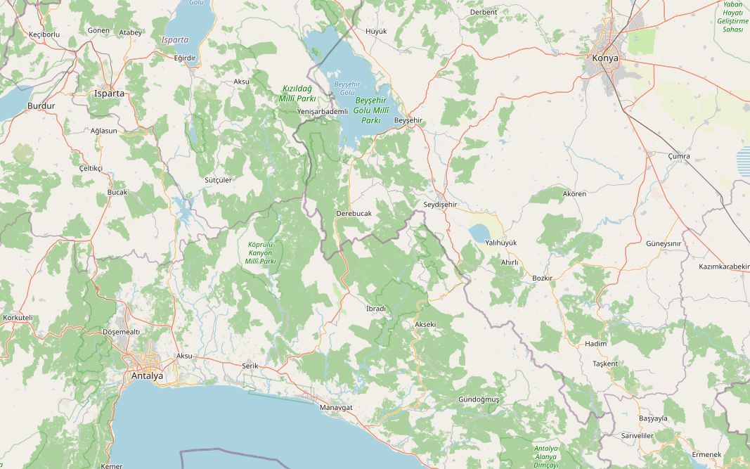
This route drops from the Anatolian plateau to the Mediterranean. It leaves Konya at about 1,000 m, runs along the shore of Lake Beyşehir, then takes the D695 south over the Taurus Mountains, topping out at 1,812 m about 159 km in, before a long descent to the coast at Manavgat and the D400 into Antalya.
The 350 km climb about 2,700 m in total. Fuel is easy except over the mountains: the longest gap is 44 km, from just past Seydişehir over the pass to Akseki, so fill up before the climb. The plan below takes two days with a night in Akseki, which leaves time for Side and Aspendos on the second day.
Along the way
- KonyaThe Mevlana Museum, once the lodge of the whirling dervishes, holds the tomb of the poet and mystic Rumi under its turquoise-tiled dome. It opened as a museum in 1927.
- BeyşehirThe Eşrefoğlu Mosque, begun in 1296, has a timber roof carried on 42 cedar columns and a snow pit in the middle that once cooled the hall. Since 2023 it is part of the UNESCO World Heritage site of wooden hypostyle mosques in Anatolia.
- Lake BeyşehirThe largest freshwater lake in Türkiye, about 650 km² with more than thirty small islands. The lake and its shores are a national park.
- SeydişehirAn industrial town known for its aluminium works. Fill up here or at the stations a little further south; after them comes the longest fuel gap of the route.
- Alacabel passThe D695 crosses the Taurus at Alacabel, and the route reaches its high point of 1,812 m here. In winter the pass is often hit by snow and drifting, and the road can close.
- AksekiA mountain town in the western Taurus, known for its snowdrops and its old stone houses; it belongs to the European Association of Historic Towns and Regions. Overnight stop.
- Manavgat waterfallJust north of Manavgat the river spills wide over a low ledge, with shady tea gardens on the bank. The falls were pictured on the old 5-lira banknote.
- SideSouth of Manavgat, the ancient city sits on a small peninsula. Its Temple of Apollo stands by the sea and is at its best at sunset.
- AspendosA short detour north of the D400 near Serik. The Roman theatre, built under Marcus Aurelius by the local architect Zenon, is almost intact and still hosts opera and ballet in summer.
- AntalyaThe end of the route. Kaleiçi, the walled old town above the harbour, is entered through the Roman Hadrian's Gate and is known for its red-tiled Ottoman houses and the Yivli Minaret.
Elevation profile
Green ticks mark fuel stations. Hover the chart to read the height at any point.
121 fuel stations sit within 400 m of the road. The longest stretch without one is 44.0 km, between km 151.2 and 195.2 (Seydişehir to Akseki). Any bike with a normal tank covers that without planning.
- 44.0 km (km 151.2–195.2)
- 29.2 km (km 6.6–35.8)
- 28.2 km (km 227.2–255.4)
Stages
| Section | km | Time |
|---|---|---|
| Day 1: Konya → Akseki | 195.5 | 2 h 41 min |
| Konya → Beyşehir | 91.3 | 1 h 8 min |
| Beyşehir → Seydişehir | 34.2 | 0 h 29 min |
| Seydişehir → Akseki | 70.0 | 1 h 4 min |
| Day 2: Akseki → Antalya | 154.2 | 2 h 10 min |
| Akseki → Manavgat | 77.0 | 1 h 7 min |
| Manavgat → Antalya | 77.2 | 1 h 3 min |
When to ride
May–June and September–October are best. Snow regularly closes the high pass between Seydişehir and Akseki in winter, and July–August are very hot on the coast.
Fuel cost
Default price: Antalya petrol, 2 October 2026.
GPS track
The full route as a GPX file, for Garmin, Calimoto, Kurviger and most navigation apps.
Download GPXMeasured: 3 November 2026