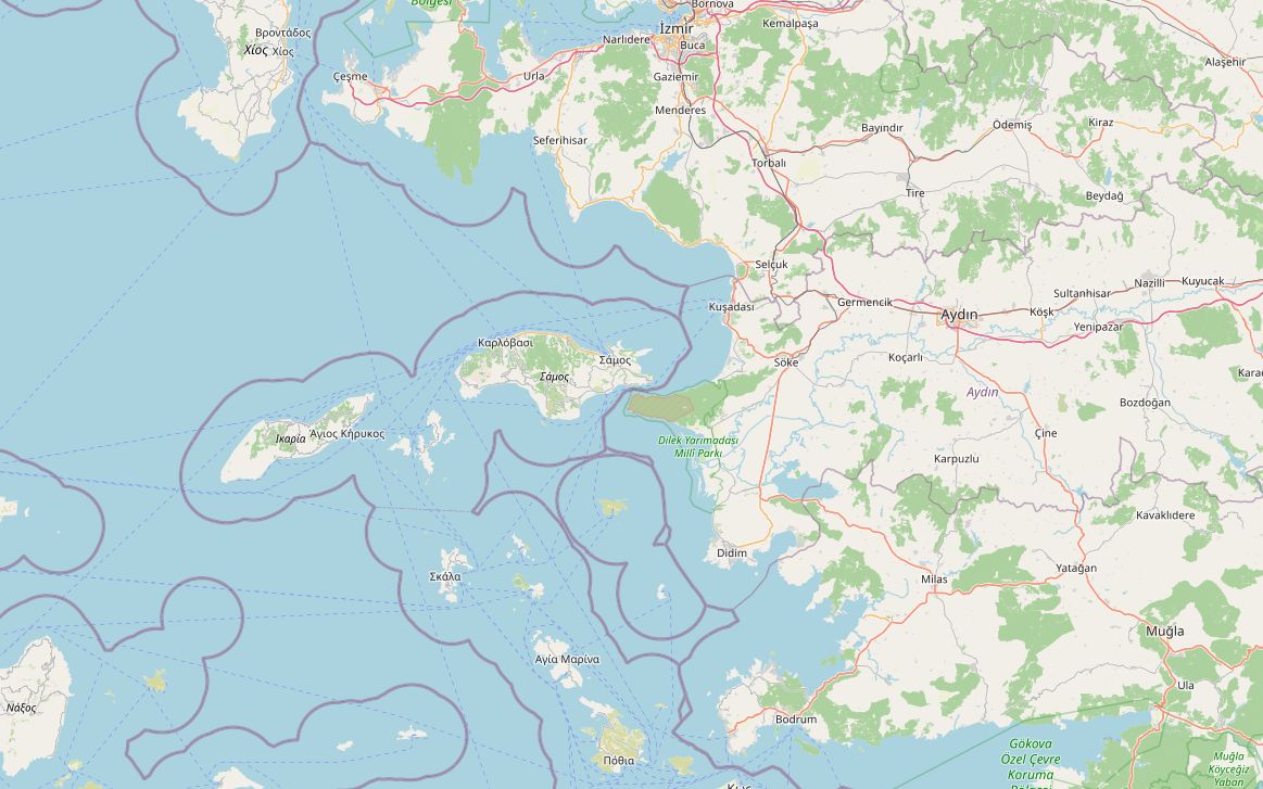
This route runs down the Aegean coast from the tip of the Çeşme peninsula to Bodrum and stays off the motorways. It leaves Çeşme on the old D300 through Alaçatı and Germiyan to Urla, instead of the O-32. From there it follows smaller roads to Seferihisar and the coast road past Gümüldür and Özdere to Kuşadası. On the second day the D515 goes to Söke and the D525 heads south toward Milas. The last stretch leaves the main road for the coast at Akbük and joins the D330 into Bodrum.
The 331 km are easy riding and the highest point is only 286 m. Fuel is easy to find everywhere except between Didim and the Bodrum approach, where the longest gap is about 65 km. Plenty of history lies along the way: Ottoman castles at Çeşme and Sığacık, Ephesus beside Selçuk, Apollo's temple at Didyma and the Knights' castle in Bodrum. The plan below takes two days, with a night in Kuşadası.
Along the way
- ÇeşmeThe castle by the harbour was built in 1508 under Sultan Bayezid II as a defence against Venetian raids. Today it houses the town museum.
- AlaçatıFounded by Greeks in the 17th century and protected as a historic site since 2005, known for its stone houses, narrow paved lanes and windmills. The steady wind and shallow bay draw windsurfers, and international races have earned it the nickname "Slalom Capital of the world".
- UrlaAt ancient Klazomenai, on the shore near Urla, archaeologists found a rock-cut olive oil workshop from the 6th century BC, built for production on a large scale.
- SığacıkA harbour village in Seferihisar with an Ottoman castle built in 1522. In 2009 it became one of the first Cittaslow towns in Türkiye. The ruins of ancient Teos are just outside the village.
- Selçuk and EphesusThe route goes through Selçuk. Ephesus, a UNESCO World Heritage Site since 2015, is about 3 km southwest and is home to the Library of Celsus.
- KuşadasıA 350 m causeway leads to Güvercinada (Pigeon Island) and its small Ottoman fortress. Overnight stop.
- SökeThe town sits on the cotton-growing plain of the Büyük Menderes. The ruins of Priene are about 15 km away.
- DidimThe Temple of Apollo at Didyma held a famous oracle. Builders worked on it for more than 600 years, but it was never finished. It was ringed by a double row of Ionic columns, each nearly 20 m tall.
- AkbükA quiet holiday village on a bay east of Didim. Fill up before you leave Didim, because the longest fuel gap of the route, about 65 km, starts there.
- BodrumThe Knights Hospitaller began the Castle of St Peter in the early 15th century, using stone from the Mausoleum of Halicarnassus, one of the Seven Wonders. The castle houses the Museum of Underwater Archaeology, with finds from the Bronze Age Uluburun wreck.
Elevation profile
Green ticks mark fuel stations. Hover the chart to read the height at any point.
81 fuel stations sit within 400 m of the road. The longest stretch without one is 65.0 km, between km 230.2 and 295.2 (Söke to Bodrum). Any bike with a normal tank covers that without planning.
- 65.0 km (km 230.2–295.2)
- 26.4 km (km 122.0–148.4)
- 20.8 km (km 11.6–32.4)
Stages
| Section | km | Time |
|---|---|---|
| Day 1: Çeşme → Kuşadası | 157.5 | 2 h 47 min |
| Çeşme → Alaçatı | 10.7 | 0 h 11 min |
| Alaçatı → Germiyan | 15.1 | 0 h 15 min |
| Germiyan → Urla | 32.2 | 0 h 30 min |
| Urla → Seferihisar | 19.3 | 0 h 28 min |
| Seferihisar → Gümüldür | 31.0 | 0 h 31 min |
| Gümüldür → Kuşadası | 49.2 | 0 h 52 min |
| Day 2: Kuşadası → Bodrum | 173.8 | 2 h 52 min |
| Kuşadası → Söke | 22.8 | 0 h 28 min |
| Söke → Didim | 52.4 | 0 h 45 min |
| Didim → Bodrum | 98.6 | 1 h 39 min |
When to ride
April–May and September–October are best. July and August are hot, and the resorts and coast roads are crowded. Winter is mild but many seaside places close.
Fuel cost
Default price: Antalya petrol, 2 October 2026.
GPS track
The full route as a GPX file, for Garmin, Calimoto, Kurviger and most navigation apps.
Download GPXMeasured: 3 November 2026